
 News
News 
- By WalkThru Media
- 01 Aug, 2026
A LiDAR point cloud and a BIM model are often spoken about as if they were the same deliverable. They are not, and the gap between them is where budgets go wrong. A scan is a measurement. A model is an interpretation of that measurement, and interpretation is human work.
What the scan gives you
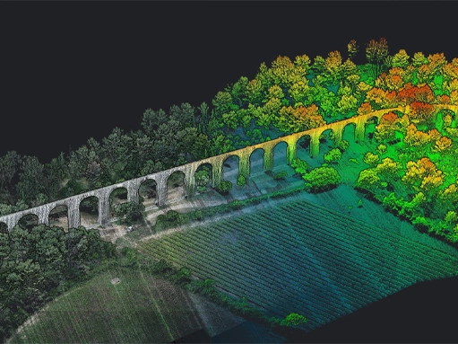
The scan produces a point cloud: a dense field of measured points describing every surface visible from the scanner's positions. It is dimensionally accurate and completely unintelligent. It knows there is a flat vertical surface at a particular location. It does not know that surface is a wall, what it is made of, whether it is structural, or where it stops and the next one begins.
For many purposes that is entirely sufficient. If you want to check a clearance, verify a floor level, or extract a floor plan, you can do all of it from the cloud without ever building a model.
What conversion involves
Turning the cloud into a model means a modeller working through it and deciding what each part of the data represents, then constructing intelligent objects to match. Walls become walls with thickness and material. Openings become doors and windows. Ducts and pipework become services with sizes and routes.
This is skilled, time-consuming work, and it involves judgement. A real wall is not perfectly flat or perfectly plumb. The modeller decides whether to model it as the idealised element it was meant to be, or to follow the deviation the scan recorded. Both are legitimate and they answer different questions, which is why the intended use has to be agreed before modelling starts.
Deciding how much detail to pay for
The most expensive mistake is commissioning more model than the project needs. Level of detail should be driven by the decisions the model will support.
For coordinating a fit-out against an existing structure, you need the structure, the primary services and anything that constrains the ceiling void, modelled accurately. You do not need every bracket.
For facilities management, you need the assets that will be maintained, with the attributes that make them findable, and much less geometric precision than people assume. A plant room modelled beautifully but with no asset data in it is decoration.
For heritage or complex geometry, the cloud itself is often the better deliverable, because modelling smooths away exactly the irregularity you scanned to capture.
Accuracy does not survive conversion unchanged
This is the point most often misunderstood. The scan is a measurement with a known tolerance. The model is a set of idealised objects fitted to that measurement, and fitting involves simplification. A wall that bows slightly across its length may be modelled as a single straight element.
So the model is not more accurate than the scan, and in the strict sense it is less so. Its value is not precision, it is intelligence: objects that can be scheduled, coordinated, clash-detected and linked to data. When precision is what matters, measure in the cloud.
Practical sequence
Scan with the model in mind, since a space scanned for visual record and a space scanned for modelling need different coverage. Agree the level of detail and the intended use before conversion starts. Keep the point cloud after the model is delivered, because it is the evidence the model was built from, and any question about whether the model is right is answered by going back to it.
Who uses the model after handover
Most scan-to-BIM projects are commissioned by a design or construction team for a specific coordination problem, and the model is treated as finished once that problem is solved. The people who then inherit it, the facilities team and whoever does the next alteration, often find it does not answer their questions, because it was never built to.
The difference is data rather than geometry. A model built for coordination needs accurate positions and clearances. A model that will be used to run a building needs the assets identified, tagged and linked to the information that makes them maintainable: what a unit is, where it serves, when it was installed. That information does not come from the scan, because a laser cannot read a nameplate. It has to be collected deliberately, on site, at the same time.
Deciding at the outset whether the model has a life after handover is what determines whether that collection happens. Adding it later means going back to a building where half of the equipment is now behind a ceiling.
Keeping the model honest over time
A model is accurate on the day it is delivered and starts drifting immediately. Every alteration that is not reflected in it widens the gap, and a model that is quietly wrong is more dangerous than no model, because people trust it.
The practical answer is not continuous updating, which nobody sustains. It is to decide what triggers a re-scan of the affected area, typically any works that open a ceiling or alter services, and to keep the original point cloud alongside the model as the reference the model can always be checked against.
What to specify when you ask for a price
Say what the model is for, which areas are in scope, what level of detail each area needs, whether asset data is required, and which software the recipients use. A quote given without those is a guess, and it is the reason scan-to-BIM prices vary so widely for what sounds like the same job.
Our 3D LiDAR scanning delivers the registered point cloud in standard exchange formats along with CAD drawings, and where a model is genuinely needed, the conversion is scoped against what the model is for rather than sold as a default add-on. We work on projects across the UAE, from towers in Business Bay to developments on Saadiyat Island.