3D LiDAR scanning outputs high-density point clouds and 3D mesh files in OBJ, XYZ, PTS, E57, and LAS data formats. We deliver 2D architectural CAD drawings in DWG and DXF formats, along with Autodesk Revit BIM model files. Spatial data integrates directly into standard architectural design, engineering, and facility management software platforms. All export formats maintain scale accuracy and coordinate systems required for professional fit-out modeling and structural engineering analysis.

Loading 0%
Contact Info
Phone
Email
Location
Khaleej Center, Office 713, Dubai, UAE
Contact Info
Phone
Email
Location
Khaleej Center, Office 713, Dubai, UAE
What We Do
3D LiDAR Scanning
Millimetre-accurate 3D LiDAR scanning and measurable digital twins for fit-out, BIM and facility management across the UAE.
From AED 199 Final quote depends on scope, volume and turnaround. Get a quote on WhatsApp
WalkThru Media provides millimetre-accurate 3D LiDAR scanning and measurable digital twins for property, fit-out, construction and facility teams across Dubai and the UAE. One capture becomes a point cloud, 2D floor plans and a walkable 3D model, so your whole team works from the same accurate record of the space.
When decisions depend on real measurements, a laser scan removes the guesswork. It is faster than manual measuring, far more accurate, and it captures everything on site in a single visit.
What you receive
- A registered point cloud of the entire space
- Accurate 2D floor plans and elevations
- A measurable, walkable 3D model
- As-built records for fit-out, renovation and handover
Who it is for
- Fit-out and interior design firms
- Architects, engineers and developers
- Facility and asset management teams
- Industrial and warehouse operators
How accurate is your 3D LiDAR scanning?
Our scans are millimetre-accurate, suitable for fit-out, BIM, renovation and as-built documentation.
What file formats do you deliver?
Point cloud formats for CAD and BIM, 2D floor plans and elevations, and a shareable online 3D model.
How is LiDAR different from Matterport?
Matterport gives a visual 3D walkthrough with approximate measurements. LiDAR delivers survey-grade point cloud data for design and construction.
Which areas do you cover?
Across Dubai and the wider UAE.
What you receive
- Millimetre-accurate scans
- Point cloud and floor plans
- Walkable 3D model
- One capture, many outputs
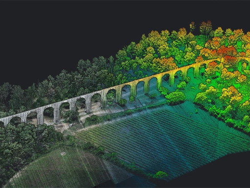
Where we deliver 3D LiDAR Scanning
We cover every major community in Dubai and Abu Dhabi, usually within 24 to 48 hours of booking.
 Before you book
Questions about 3D LiDAR Scanning.
-
01. What file formats do 3D LiDAR scans generate for architects and CAD users?
-
02. How accurate are 3D LiDAR digital twin measurements?Professional 3D LiDAR scanners achieve measurement accuracy within 0.5 percent or 2 millimeters over standard structural distances. Infrared laser sensors capture millions of precise spatial coordinate points per second across floors, walls, ceilings, and MEP mechanical installations. The resulting digital twin delivers reliable dimensional data for architectural fit-out planning, floor area verification, and retrofitting calculations. Architects verify structural clearances directly within digital point cloud files without taking manual field measurements.
-
03. Can LiDAR scanning produce schematic 2D CAD floor plans?WalkThru Media converts 3D LiDAR point cloud data into detailed 2D CAD floor plans showing exact wall thicknesses, door swings, and window locations. Schematic floor plans include accurate room dimensions, gross internal area calculations, and structural column grid placement. AutoCAD files are delivered in DWG and PDF formats within 48 hours of completing on-site laser scanning. Architects and interior designers use these verified base plans to initiate fit-out design proposals instantly.
-
04. How long does LiDAR scanning take for a large commercial asset?Scanning a 20,000 square foot commercial space or shell-and-core office floor takes approximately 4 to 6 hours on site. High-speed Leica LiDAR hardware captures individual scanning positions in under two minutes, covering extensive floor areas efficiently without operational downtime. Field technicians systematically cover open areas, mechanical rooms, corridors, and structural perimeters. Complete digital point cloud processing and technical file exporting require up to 48 hours following field survey completion.
Our clients
Trusted by developers, agencies &
Trusted by developers, agencies &
property owners across the UAE.
A few of the teams we work with, from launch campaigns to live listings.